The Coastal Portal updates its static map collection
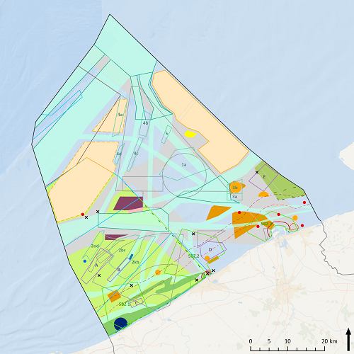
New data was added to the static maps, meaning that they are now fully up-to-date with the new and second marine spatial plan (MSP) for the Belgian part of the North Sea, which will be in effect from 2020 until 2026. The marine spatial plan tries to merge the different uses of the Belgian Part of the North Sea (BPNS) such as maritime transport, fisheries, nature reserves, sand extraction and renewable energy. This new version contains some important changes and novelties:
- New zones for renewable energy: the offshore wind energy capacity in the Belgian part of the North Sea will double. The Belgian government reserved a zone of 238km² for offshore wind farms. Check out the new static map here.
- The artificial island project for storm protection in front of the coast of Knokke has been put on hold.
- A new nature conservation zone “Vlakte van de Raan”.
- Optimization of existing zones for defence, sand extraction and dredging.
- Space for the development of commercial and industrial activities (in the context of the blue economy and growth).
In addition, 2 new static maps were added: salinization and open space. In the MSP, open space means the part of the Belgian part of the North Sea where no activities take place so far. The map on salinization is also available as a dynamic map layer and can be accessed through the recently added theme ‘Climate’. For more information on the MSP:
- Current MSP (2014-2020): summary brochure.
- New MRP (2020-2026): full plan and comments.