EMODnet launches Vessel Density Map 2017
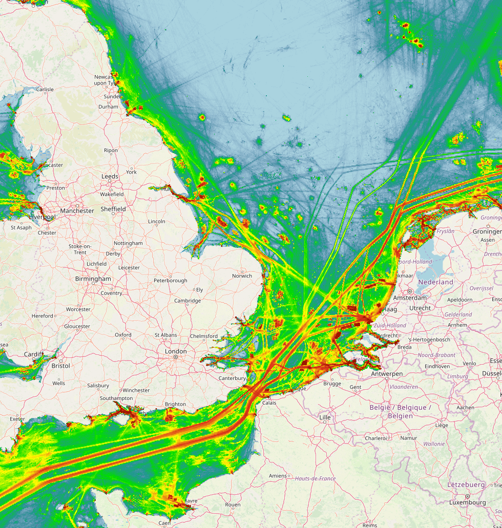
News of the publication of the "Vessel Density Map 2017" was circulated by EMODnet through a press release on the 11th of March. This rasterlayer displays the monthly average density of maritime traffic in European open waters for 2017. The spatial data product allows users easy access to information on the movement and distribution patterns of different types of ships that move over European waters. It uniquely enables those responsible for multiple human activities to freely use these spatial information in the planning of their activities within a zone of interest.
The density values are defined as the amount of time a ship was located within a square kilometer during the respective month, and can be filtered based on 13 different ship types. A color gradient makes it easy for users to detect where the busiest areas are located. This could prove convenient for highly used areas, such as the Belgian part of the North Sea. Data used to create this spatial data product was collected using the 'Automatic Identification System' (AIS), which continuously tracks shipping movements using transponders on the ships. The method by which the raster is constructed was developed in agreement with the Joint Research Center (JRC) of the European Commission. A detailed explanation on the methodology can be found on the website of EMODnet Human Activities.
 The raster layer can be accessed through the EMODnet Human Activities Portal or the EMODnet Central Portal. At this time, only a layer for 2017 was created with a equivalent for 2018 planned in the near future. As open data is a key feature of EMODnet, the spatial data product can be accessed, downloaded and processed freely for both commercial as well as for personal purposes.
To further detail this product, as well as providing further information on the methodology, a live tutorial is scheduled on the 15th of March. From 10 to 10.45am, Alessandro Pititto (EMODnet Human Activities Coordinator), Luigi Falco (GIS Coordinator) and William Adnams (GIS Developer) will give some insights into the product. Registration for this tutorial is done through an email to webinar@emodnet.eu.
As the layer is of great value for the highly used Belgian part of the North Sea, it was also added to the collection of dynamic layers within the Coastal Portal. It is accessible through the dynamic viewer, or within the 'Maritime Transport and Harbors' theme.